Thursday, November 15, 2007

Ragati River - Kenya


James Savage. A first descent of the Ragati slides, Kenya

The Ragati River is another primary artery to the Mt. Kenya drainage system that we were hoping was going to put out impressive results. On this side of the mountain the bedrock had somewhat changed from the pool drop nature so commonly found in the lava-like gorges nearby. Instead, the Ragati was known to have super slides one would hardly expect in this part of the world.


A weekend came about with the crew ready, and water levels ideal so we set out on a ground mission first to see what we could find on foot. Already the night before when the topo map was on the table, Simon had given us his word that there would be plenty more slides above the 1 and a half he had ran when he was here in 2004.


Within an hour from basecamp, we were walking easliy along the shore getting some interesting looks from local farmers, mothers and children who were least expecting 3 muzungus thrashing through their banana and coffee plantations while checking the river. From where the 1st descents of the slides left off in 2004, the original slide conqueror and myself headed further up the drainage to discover more of the goods that had been waiting patiently for our return.


The Ragati slides start of with a 200+ foot two-tiered monster slide that began with scouting discussions of ' yeah right' into 'ugly-hmmm' into 'interesting' as we neared top. Probably a good thing that we were walking from the bottom up. But in the end some of us were only willing to give the top part a go and this was going require more safety that we had. Beyond, the slides again pick up in size until Bamboocha hurls another 100+ feet of instant gravity loss your way.


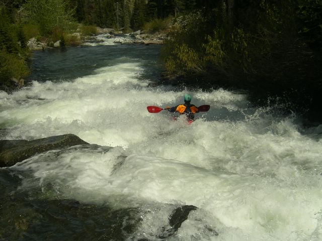
Simon Coward drops in.

After Bamboocha, a few smaller ramps appear and a tight class V slot drop makes the Ragati feel like more than just a African supersized waterpark. Over a dozen slides later, including a grand finale on the original from 2004 that caused a near decapitating from the fierce shore vegitation, we were down on the flats with darkness fast approaching. The Ragati is currently one of Kenya's sweetest paddling discoveries. Until the next group appears, it is a fine symbol in the search for quality creeking in a region where whitewater has no face.

Monday, November 12, 2007

Muragua River - Kenya


Simon Coward likes his boofs big. Muragua River - Kenya

After the past few weeks in Kenya it is hard to believe that I left Europe only a month ago feeling confident that I would not be missing nor needing my trusty Dagger Nomad that I had practically been living inside since June. Impressions of African big waves and endless blunt movies that have swamped the internet highway over the past few years had me mislead. But it was my friend Simon back home that had always been the secret source of the truth. Nearly 4 years prior, his adventure insights brought him and a kiwi crew to a paddling destination far from ordinary.


Lower Muragua Gorge.

Lying on the equator, Kenya is more than a country of grasslands and grazing zebras. Africa's second highest, Mt. Kenya and many other mountain ranges, contribute to a spectacular landscape and provide an enormous area of altitude and water that has to drain somewhere, somehow. No longer is it a fanciful thought. Kenya can convert you from vacation bluntboater to a creekboater in a matter of days.


A massive component to Kenyan river exploration has come from Marc and James Savage. Beginning as a bush pilot and mountaineer, Marc founded whitewater rafting and adventure tourism in Kenya. Marc and family are keeping things active with a river base paradise on the Tana river. However James is keen in the kayak and his goal of river exploration remains.

First descents are vast in this country, but the Muragua River was one of Simon and crew's original mission discoveries. Years later and none kayakers more it is still a short but swift gut punch of rad.


James Savage close to home.

The Muragua appears after miles of bumpy road at a bridge over a sweet slide to start things off. The friendly locals quickly gathered in conversation about today's unexpected entertainment. Eyes, hoots and smiles were to be the norm.


The Muragua is tight at the beginning, but soon opens up to what any adventure paddler seeks. Easy access, clean drops, and a highlight waterfall.


Meat-2-the-vapor.

Further downstream beyond the KenGen dam, the Muragua plummets itself off an 80 foot waterfall shelf and into a gorge full of giant drops still waiting for a kayak to show up.


Here the access can be an issue as we found ourselves swatting through thorn bushes and sliding down drainage cracks to get down below the entry falls. There is so much action in this one drainage alone it is hard to imagine what could be lying just around the next corner or over the next hill. But already nearing 5:30 the sun is low and the scale of the whitewater ahead must be saved for another time and day. Wearing the red soil as the color of Kenya on our hands and clothes, we return to Sagana after a special day of whitewater in Africa.


View Maragua River (IV) in a larger map

Wednesday, October 10, 2007

Soča (S - Gorge Cataract) - Slovenia


Diego Budeguer in the heart of the Soča River - Slovenia

The Soča river is far from being a secret to the European whitewater scene. For much of a 7 month long season, the Soča remains loyal to road tripping clubs visiting from afar, weekend warriors from neighboring countries, and locals soaking up the summer.


Julian alp views are vantastic.....

Besides the endless spring source welling up deep inside the Julian Alps, the Soča’s biggest attribute is the straight up combination of beautiful surroundings, crystal clear water and natural slalom eddies formed from the unique ghostly shaded karst rock.

Few paddlers leave the Soča unfulfilled. It is considered one of the most beautiful classrooms in whitewater. Even the strongest paddlers find some degree of satisfaction in the perfectly situated rocks, unique boofs and multiple sections of class II-IV.

The quality rapids and technical lines making the Soča a classic are also here. The Soča delivers the goods in a 2km stretch notoriously branded the Siphon Gorge.

The rocks in this stretch are bigger, tighter and can leave you wondering about safe locations on your first few runs down. But eddies always outnumber the siphons, and with good flows and a good group the S-Gorge of the Soča turns into a sweet, endless, boof to eddy playground.


Thanks to Laurent Devigne (FRA), Diego Budeguer and Fabian Bonnano (ARG) for great photos, lines and friendships during our week.

Saturday, September 01, 2007

Lower Raundalselva - Norway


Mike Abbott starts off in sun and style, Lower Raundalselva - Norway

The Raundal of Voss is one of those rivers that offers multiple class III-VI sections of whitewater throughout a long season of varying water levels. Throw in some deep gorges, must run boofs, numerous waterfalls, 30 kilometers of river, and Voss's reputation as a creek boater's paradise soaks in. With a past week of high cloud, cold nights and clear skies, the water levels in the area dropped enough to bring the class IV-V Lower Raundalselva onto the minds of a few of us.


The Raundalselva needs manageable flows of around 20 or less cms to keep the nerves calm in a few not-so-clean boulder chokes within some deep walls. Even before you get into your boat, you are staring down the entry to a beautiful 20 foot waterfall. You can either go left for the boof here, or maybe try your luck down a clean slide on the right of the rock island.


Put in huck choices - and how about that sunny weather!


Mike with the new Palm max floatation PFD.

Not too far into the run comes an unappealing no-scout drop with big rocks taking up the majority of the horizon line. Again you have the choice to boof the left pinch and bounce off a rock at the bottom or go right through a winding corridor that puts you close to some sieves. Another drop worthy of mention lies just downstream and has an undercut rock blocking half of the exit on the right. The river stays fairly gorged up from this point on but offers slippery green covered rocks on each shore to scout or portage for the rest of the run.


Andy Phillips enjoying his relaxing float in the pool between drops.


Greg Dashper - happy times.


Michelle Basso - left line highlight waterfall close to the end of the gorge.

You will know you are nearing the end of the gorge when the gradient flattens out and the pools become clear and large. After the walls disappear paddle the flatwater for a short distance and take out on your right at some red army buildings. Thanks to Benjamin Hjort and the riverkore boys for the good lines, humour and a most perfect day in Voss.

Monday, August 27, 2007

Hemsila - Norway


Huck happy on Norway's rare flowing Hemsila.

Hemsedal is one of Norway's premier winter freeride resorts, but in the summer things quiet down substantially. This is the current home of the always impressive Jim 'farmer diesel' Cummings. Besides Motocross and Mtn Biking hard, he is out there making friends with the locals and trying to avoid the 1500 dollar speeding-in-Norway fines while on the prowl for quality class V. The Hemsila just happens to be a top 10 Norwegian creeking gem in Jim's own backyard. However a stingy dam and whole lot of rain this summer has made it difficult in finding the perfect 15-25 cms needed for a safe passage through its double canyons. South African, Hendri Coetzee brought the sun with him on his few days off from work and we converged in Hemsedal to make things happen.


Our first attempt at the Hemsila with a flow of over 40 cms resulted in consistent pucker factor and portage party along the canyon walls. But after 2 days of patient waiting in rare dry sunny heat, the level nearly dropped in half and we were in business as long as the dam kept their gates open for one more day.


The Hemsila starts off in mighty fashion with a tight slot drop to begin the first canyon, letting you know right away the importance on having water levels that aren't pushy.


One portage will probably happen in this warm up canyon before things open up again providing easy scouting to the many slides and drops that lead up to the REAL canyon.
At this point there is an alternative takeout bridge above a monster drop (portage), followed by a 100+ footer slide requiring a crucial left line to set you up for the final plunge.


From this point on the Hemsila turns into a class V box gorge puzzle that your skills and patience need to solve in the remaining 4-5 kms. Two must run rapids in this canyon still have eddies to slow things down and help you get a fix on the lines downstream.


In the final kilometer before the town of Gol comes a slide with a vicious hole followed by 3 waterfalls. If your body and mind decide to conquer these final drops make sure you are feeling invincible and there is plenty of safety. A water level in our opinion of less than 20cms would also make things easier. On our way back to Hemsedal came good feelings about the descent and our accomplishments. As we drove by the dam the water had already been turned off, meaning we had chosen the perfect day of the summer to paddle Norway's classic Hemsila.


Thanks to my beautiful wife for the awesome photos.


View Hemsila (V) in a larger map

Sunday, August 19, 2007

Myklebustelva - Norway


How I spent my summer vacation..... Jordie Mckenzie, Myklebustelva - Norway

The Norway whitewater experience is always an adventure full of sweet lines and surprises. This year has been no different except for the fact the tap has yet to be turned off. Many rivers are still banging out huge flows. With lots of water brings the search for new descents in a land where water runs down anything with gradient. Norweigans are proud of their land and those who go hunting for the treasure of slides and drops sometimes find secret spots right in the backyard. Øivind Kleppe and Nils Hjelme were kind enough to tell us of their secret after work spot. Having seen only a handful of descents, the Myklebustelva is a tributary to the classic Valdolla, lurking in fjords of More Og Romsdal.


Although only given directions by mouth, an hour's stroll through mossy enchanted forest revealed more than I had hoped for. A dozen or more drops packed into less than a kilometer of distance - a park and slide 5 star hotel. After 3 bombs down a run with only small pools keeping the drops from being one giant slide, safe to say the grin on everyone's face was wider than the crystal creek they had just paddled.


Just like back home, the Norway 'mission' will always be here.....long live the search.

Monday, June 25, 2007

Bighorn River, AB - Canada


Crescent Falls backdrop with Mikkel St. Jean making the Curtain Call - Bighorn River, Alberta.

The Bighorn River is a classic waterfall tributary of Alberta’s North Saskatchewan headwaters. In a setting amongst the raw jagged Central Canadian Rocky Mountains, the Bighorn has found away to erode itself into a deep layered gorge with 6 beauty drops within its walls. The run is heavily dependent on snow in an area commonly low in annual amounts. This usually makes for a limited window of opportunity for paddling. However, the endless thunderstorms rolling across from BC currently had this waterfall paradise pumping.


Among the usual suspects for this mission were Jordie and Jen McKenzie, Manilow, Chris McTaggart, Nelson BC local Mikkel St. Jean still waiting for levels in BC to drop; and fresh off a second descent of 100ft Johnson Falls was heavy hitter Logan Grayling complete with bloodshot eye and the savage mustache.


Logan Grayling boofs must run freefall #5

Getting to the Bighorn is easy requiring you to travel west along the David Thompson highway through Nordegg towards the Banff National Park Boundary. If you are coming from the opposite direction head north on highway 93 from Lake Louise and then head east towards Nordegg at the Saskatchewan Crossing turnoff. The Bighorn River crosses the highway through giant culverts at the end of Abraham Lake. You can camp and leave a car here and then continue back towards Nordegg looking for the Crescent Falls turnoff just down the road. The road up to Crescent Falls is only a few miles and ends at a recreation area parking lot.

Only a few steps more will put you at the brink of a 70 footer that is still waiting for someone to claim this monster for a first D. Most of us regard the problem with Crescent Falls to be all the loose sediment of sharp rock which explodes out from the boils when flows are most appealing. If ever you were going to wear a motorcycle helmet complete with visor off a big huck this would be the one. A bonus for your eyes is just beyond and another 40+ feet to go.

Curtain Call was first run by Rob Evans-Davies about a decade ago and has since seen a few more descents over the years. Again the line on this waterfall varies with water levels and this time it looked to be center left with left control.

Chris McTaggart lost the fight with his paddle shaft on Curtain Call

Beyond the second waterfall you are surrounded by deep walls on your way down to the Particle Accelerator. Here the river ramps down into a narrow slide that ends in a big hole complete with pinched exit and a scary cave on the left. At lower flows you might just get your bow up before the hole and boof. However the current level made for some impressive downtime as saftey pondered the resurfacing whereabouts of each mystery man.


Just beyond here the final 3 waterfalls lay in succession about 100 yards from each other. 10 foot Squirrel Nuts, 25 foot Freefall, and then a final 20 foot plunge into a pool. All of these are pretty much unportageable unless you like cliff jumping from twice the height of each drop. Finally a half hour of class III awaits on your way down to the takeout.


Jenny McKenzie on the final drop of the Bighorn.


To best judge the flows for the Bighorn have a look to see if any water at all is flowing through the second culvert. If there is just a bit the levels are good, none means the level is low, and lots means the river is high. Standing at the top of the two first falls will also give you an idea.


View Big Horn River (IV-V+) in a larger map

Monday, June 11, 2007

Big Timber Creek Race 2007, MT - USA


Bryce Shaw airbrace to switch - Big Timber Race -2007

The first ever Big Timber Creek Race took place over the weekend with over 30 competitors stepping up to fire off one of the steepest sections of downriver racing on the whitewater map.

Special thanks to race organizers from Headwaters Paddling Association, great sponsors, landowners in the area and everyone who came to rage down Big T any which way they could.

Pinch Runners Results:

1. Chris McTaggart
2. Mikkel St. Jean Duncan
3. Spencer Cox
4. Ira Vasgaard
5. Patrick Rodgers
6. Mark Basso
Logan Grayling
8. Bryce Shaw
9. Doug Marberg
10. Bradford MacArthur
11. Chris Baer
12. Graham Storey
13. Chris Newey
14. Todd Richey
PJ Moran
16. Cooper Brightman
17. David Binkley
18. Aaron Loft
19. Barry Bohr
20. Will Hartman
21. Matt Sylvester
22. Chad Wiebe
23. David Schroeder
24. Steve Rodgers

Gamblers Results:

1. Andy Hoover
2. Ian M
3. Jeff Lessley
4. Jeff Clark
5. Randall Cook
6. Jonas Grenz
7. Jason Matthews
8. Mike Goglin


Big Timber report from last year's mission:
___________________________________________________________________

In the constant search for the backyard dream run it was most excellent to come upon a classic steep creek which actually does exist within a tank of gas from the house. Like the classic slides of California, Big Timber Creek is also proof that you don't need to travel all the way to Norway to get the super slide kayaking fix.


The Pinch.

Flowing from a fairytale backdrop with a gradient of over 700ft per mile, Big Timber is certainly a short run of epic scale. The Crazy Mountians simply rise up from a portion of Montana prairie like an oasis of rocks. Our Calgary crew of 3 strode across into Montanada with high hopes of dropping into slide infested Big Tim upon arrival. However while discussing flows in Bozeman with the Garcia brothers our conversation became flooded with talk of too much water. Only the week before, high elevations in the area were still receiving snow and now all of a sudden Bozeman was back to mid 80 degree temperatures. Only a couple days before Evan and Ian had mixed results on Big Timber's lower falls at high water and were sent home with a black eye and roughed up hands.


Posted by Picasa Found some wood.

We decided to put our Big Timber anticipations on hold until later on in the week and instead headed over to the Stillwater and Boulder creek drainages. Both of these areas were also seeing a sudden purge of snowmelt but fortunately the only carnage we saw came from Joey bagging his Toyota on the back roads.


Hung up like a fresh kill....Joey Vosburgh post muffler. Posted by Picasa

On the eve of moving on from the Sawtooth Mountains and heading over to Missoula, we sat in the Columbus truck stop looking at the map and decided that Big Timber was just too close not to at least go camp at and scout the next day. In the morning we awoke at Halfmoon Campground to the sound of the water romping below our trucks. Coffees in hand, it took only a short walk up past the lower falls to commit to paddling the creek we had drove the 500 miles to claim. By local standards it was high, but indifferent to customary knowledge, we still saw plenty of eddies on the hike up and quickly began recognizing some of the drops from films and photos.


Chris Baer on the first drop.

Big Timber Creek starts off with one of its few near vertical drops on the upper section before turning into slide-pool slide for a majority of the gradient. Most of the slides are steep enough to make you forget about the abuse your creeker's hull is taking and a couple long slides put you near the euphoric state of creekboat bliss.


As our afternoon wore on we realized we weren't the fastest on the way down and a long scout of the 70 ft super-slide pinch near end began to make us wish we had brought more than a few energy bars. After running the pinch, the last few drops put us on the brink of underperformance and we decided to come back another time to run the lower falls.


Jordie MacKenzie - Lower Big T Falls July, 06


Unless you are one of the lucky Bozeman/Livingston Boaters who get to spend countless hours of worship sliding out of the Crazy Mountains during the snowmelt, hardly enough acclaim can be given to Big Timber Creek off a quick road trip. As always for those who appreciate summer in Western North America, Montana beckons……


Posted by Picasa