Saturday, November 26, 2005

Astoria River, AB - Canada


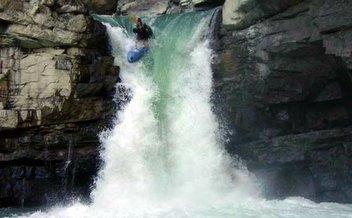
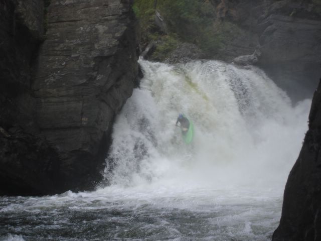
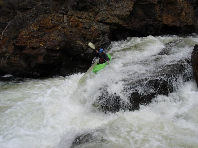
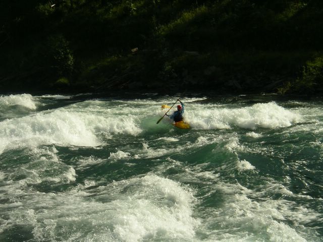
Scott Feindel setting up for the canyon entrance on the Astoria River - Jasper National Park, Alberta. Posted by Picasa

As we hang up the paddles and pull out the snowmobiles and skis here in the Great White North, one can't help but smugly reflect on a most interesting paddling season that was greatly enjoyed by many Western Canadian river rats such as myself. Expecting a lousy runoff due to mediocre snow pack, this was greatly altered thanks to a month of huge rains last June. The window of river running opportunity multiplied tenfold over the course of a few weeks and even to this very day, dams are still running at 100%. The water tables across the province of Alberta have never looked better.

One of the rivers that enjoyed an extended season is a Rocky Mountain classic located just outside the mountian town of Jasper. The Astoria has long been considered a special river among creekers past and present. Although it is not the sickest run in the West, a combination of easy access, pristine Jasper National Park wilderness and continuous gradient put the Astoria high up on summer tour schedules. Paddlers who know the Astoria routine and are confident running the final class V canyon can pull off a morning blast and be back on a Jasper patio sipping brews by lunchtime. From here, it is an easy drive west one hour to the classic big volume water found in the upper Fraser.


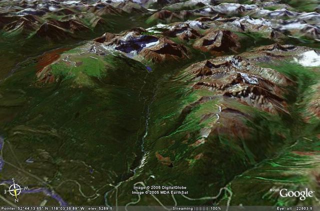
A satellite image of the Astoria River courtesy of Google Earth. Posted by Picasa

The Astoria would probably be a multi-day mission if it weren't for the paved road giving summer tourist access to Mount Edith Cavell and the hanging Angel Glacier. About 1km before the main parking lot at the end of the road look for the Tonquin Valley trailhead and park your vehicle here.


Gearing up at the Astoria put-in with Mt. Edith Cavell in the background. Posted by Picasa

Follow a short stretch of the trail to the bridge that crosses Cavell Creek. You will only hear Cavell Creek as most of it now runs underneath a bed of large rocks which you will find useful to walk on. Head down the boulder bed and once the rocks lose their size and the creek reappears, move to the right shore and make your way through the brush until you encounter the calm meandering Astoria at the bottom of the valley.


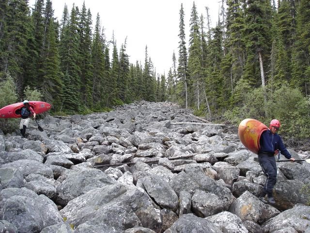
Joey Vosburgh and Colan Morrow on their way down the boulders atop Cavell Creek Posted by Picasa

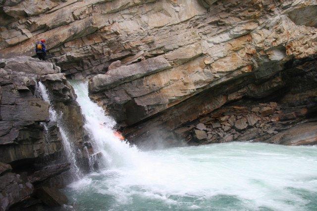
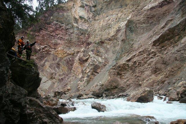
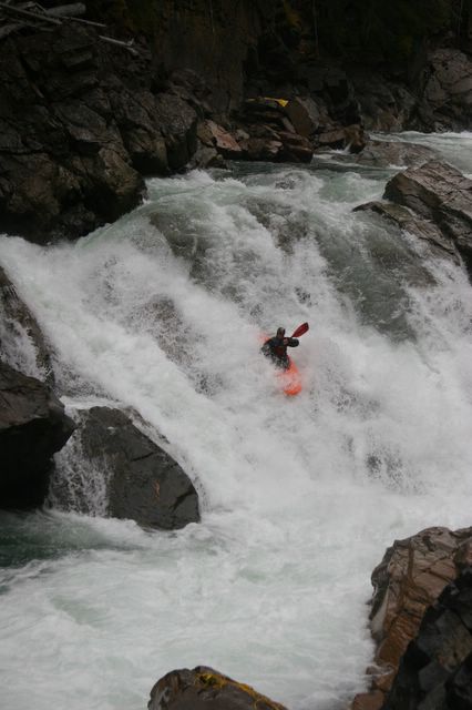
The Astoria will begin to take off in a continuous bed of boulders less than half a kilometer from the put-in. Depending on the flow, either there will be some bumpy sections or you will be wanting to space yourselves out as you begin to speed down a ribbon of white. Don't be too surprised if you can't find an eddy able to hold more than one kayak. If the water is high you will find yourself in an endless but manageable torrent of whitewater bliss making lots of quick technical moves and hopefully keeping your kayak pointing downstream. After about 5km, the river becomes even steeper and it is time to begin looking for a steep left sweeping turn that ends in a sharp right corner at the canyon entrance drop known as the Howler. You can get out on the left well above this section and walk down to the entrance of the canyon to scout. If the canyon entrance drop looks really nasty, this short but intense canyon will contain several very difficult lines including a river wide hole located just downstream of the entrance.


Scott Feindel keeps his speed through an unpredictable hole downstream of the canyon entrance. Posted by Picasa

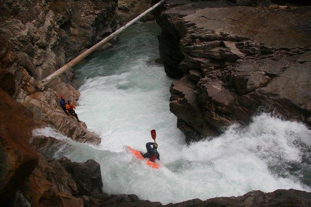
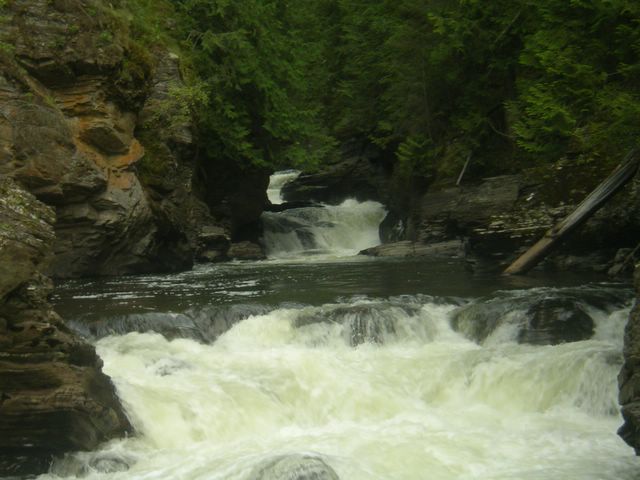
A bail out option is to head up the river left slope and portage the entire canyon. This option is not as bad as it looks and can be done in less than an hour. The canyon ends in a beautiful pool backed up by a small diversion dam perched on the edge of an unrunnable walled waterfall. Carry your boat down the dirt road and you will come to the main road and bridge that crosses over the Astoria. If you haven't had enough you can put back in and run 3.5km more of the Astoria as it flattens out into grade II before joining with the Athabasca River Valley.


Looking downstream from the take-out at the crazy rapids below the diversion dam. Photos courtesy of Jordie Mckenzie. Posted by Picasa


View Untitled in a larger map

Tuesday, October 18, 2005

Spillimacheen River, BC - Canada


Raymond Schmidt gets a close-up of the last drop, Spillimacheen River - Canada
Photos thanks to David Faubert. Posted by Picasa

The Spilli is the paddler's answer for a class V fix long after most creeks in Southeastern BC have gone into winter hibernation and are ultimately dry. The upper reaches of the Spillimacheen River begin deep within the Dogtooth Mountain Range, famous for winter backcountry snow greatness. Of course once the snow turns into liquid form, it creates abundant water levels throughout the summer. Most of the steep goods lie within the final 2.5km gorge just before the Spilli's final run out into the Columbia River basin. In such a vast BC watershed it is no surprise that a hydroelectric plant was also created in this high gradient section of the run. Fortunately it is the amount of water being diverted that makes late autumn water levels perfect for running possibly all several drops within.


Nice geology and some tight lines as well. Posted by Picasa

It used to be hard enough just to piece together a group of boaters in Calgary looking to run the shit only a few weeks before winter officially arrived. Yet my phone found a way to make it happen. An early Sunday morning drive found Spencer, David, Ray and I heading over the continental divide into a significantly warmer Columbia Valley. Thankfully creeking was still on the agenda mid October in the Rocky Mountains.

Once you are over the dam spillway and into the canyon, you quickly realize how fortunate you are to be able enter this committing stretch with just the right amount of water. The rapids begin to come quickly in succession and on the second drop you face a tight line putting you onto a slide that ends in a funny hole. Out of this drop begins some great boulder gardens with plenty of lines to lose yourself in.


Posted by Picasa

The next significant stage of the Spilli is when the boulder garden narrows and finishes in a nice ramp drop. This drop requires making a tight line just above the rapid between two big boulders that may have pin potential. Beyond this you enter the heart of the gorge with two drops aptly named the "pink" and "stink". Most of our crew decided to only run the top drop and probably made a wise decision as I personally found out how stinky paddling into an L shaped drop with a viscous hole and no hull speed could be.

Posted by Picasa
Good safety was a good thing dropping the Stink.

Upon getting around the stink, all that is left in your way is a beauty 15 foot waterfall to seal the deal and send you floating down to the take-out bridge.


Spencer Cox goes right line off the falls. Posted by Picasa

The Spillimacheen River is located about 50km south of Golden BC or 35km north of the town of Radium on route 95. Take a left onto Westside road once you reach the settlement of Spillimacheen and then continue 2km until a right turn onto the Spillimacheen Forest Service Road. From here the take-out is your first bridge crossing and the put in is another 3km upstream on the left at the reservoir.


Vis Spillimacheen River (V) i et større kart

Friday, September 30, 2005

Raft River, BC - Canada


4 hours into... and now quite amongst it. Raft River, BC - Canada Posted by Picasa

Although it has a name that sounds inviting to those seeking rubber tubes and raging water, the Raft River is one of those deceiving BC runs that probably won't see a raft descent for a very long while. In fact, whoever it was that decided to first attempt the Raft's lower box canyon successfully must have been having a fearless paddling year and adventurous thoughts.


BC water at its finest. Posted by Picasa

I actually first heard talk of the ominous Raft being ran (probably for 2nd or 3rd time) from un-BC-local Clay Wright while I was paddling in the Southeastern US during the Spring of 2001. Although he couldn't quite remember the name of the run which he and some friends had stumbled upon during a late summer roam through BC, the fact that it was "Near the Clearwater River, DEEP and.... VERY SWEET", left me quite intrigued and wanting to investigate. The next summer during my annual round of BC creeking, I discovered what Clay was describing as I dropped deep into the final kilometers of the Raft River gorge.


The final few drops on the run before Raft Falls. Posted by Picasa

3 years came and went however, before I was back again paddling that first stretch of the river trying to describe what was about to be upon myself and Jordie McKenzie, my only willing paddling companion. Although the Raft meanders lazily from the headwaters near Wells-Gray Provincial Park, the final push to the confluence with the North Thompson is through 4-5 km of tight technical drops in very inescapable and intimidating surroundings.


Hmmm.... I guess we're paddling out . Posted by Picasa

The secret of running the Raft's canyon requires a crucial assement of the river's flow. Don't even consider this run in early summer or after big rains. The river does pass underneath the Yellowhead Highway where you can get a quick glance, but it is better to turn onto the Raft River Forestry Road and walk up to Raft Falls past the sawmill next to the river. A quick path through the sawmill and down to the river will reveal a local swimming and cliff-diving hangout with a 20ft waterfall. Raft Falls should look runnable and have an adequate amount of water in comparison with the wide, calm and shallow water that continues just downstream. Running the waterfall is your only ticket out of the gorge and will mark the end of an amazing creeking experience should you decide to put on.


A sweet huck off Raft Falls to finish it may seem anticlimatic after 5km of box-canyon head games. Posted by Picasa

From the sawmill, the forestry road climbs steeply up along the river right shore. Around km 14, another forestry road will fork off to the right and quickly cross the Raft River where it will be flowing calm and flat. Put in at this point and you will need to paddle 3-4 kms of flatwater before the river steepens and the canyon begins to form. You will know when you've reached the crux of the run once the river starts to drop through some ultra narrow and difficult slot drops. One of these rapids is VERY questionable because if the water is too high it does not have any eddies to catch above. It also has nowhere to set safety and requires a high cliff jump into the pool beyond it. As we found out, we were staring around at the canyon walls for a very long time trying to make a good decision. However, with patience and plenty of adrenaline boofs later we came to the end of it all.


Jordie McKenzie now fully desensitized to the task at hand. Posted by Picasa

The Raft River well represents class V creeking in an intimating yet beautiful environment commonly found in the Britsh Columbia wild. Although the canyon is short, it certainly will leave you with something to tell others about even if you do happen to forget the name of it. The run is located less than 10 km east of the town of Clearwater BC heading towards Jasper.


Posted by Picasa


Vis Raft River (V) i et større kart

Thursday, July 28, 2005

Ula Foss - Norway


Walking to the put-in on the Upper Ula, Norway Posted by Picasa

The Upper Ula is a low volume creek containing the best of what Norway has to offer paddlers – amazing scenery, big slides and waterfalls, a little something for everyone. From the town of Otta near the Sjoa valley a steep winding road quickly climbs above treeline into Rondane National Park, one of Norway's classic trekking spots. Once the road turns to dirt, go left and pass through the toll gate and head further up the main hill covered by shrubs, goats and traditional houses with lots of grass on their roofs for insulation from the harsh winters.


Posted by Picasa

At the end of the road is a parking lot for hikers and a 5 minute walk will get you to the water.

From the put-in the first section is a nice easy warm up with some easy slides and drops to get you prepared for what is coming up. After portaging around a beautiful waterfall, the river enters a small gorge and starts to pick up in gradient.


Kim Siekerman on one of the drops before the portage Posted by Picasa

Just past the end of the mini gorge comes two more significant drops before the start of the slides.


Jonothan Church on the second section of the Ula slides. (video)

The slides are what most people come to the Ula looking for, here the creek drops over 2-3 slides more than 200ft long before ending in a sweet 15 ft waterfall. The line on this drop is tight if you want to avoid flying off the left side and onto a hard shallow landing.


Airing out off the waterfall below the slides. Posted by Picasa

After the super slides the Ula resumes at an easier pace but still contains many small drops and slides before the run culminates at the four classic Ula waterfalls. The first 3 falls (20ft 7ft 15ft) are quite runnable at most flows while the last 40ft waterfall is rarely ran successfully.


Classic Norway huckin'-Ula Falls, Norway Posted by Picasa

Just before the waterfalls is a road that will get you back to a lower parking for the take-out. Whether you come for quality slides, multiple waterfalls, or just to boof some fun drops in the alpine scenery, the Ula is certainly a Norwegian classic if you get it at a good water level.

Tuesday, July 19, 2005

Sjoa River - Norway


Michelle Basso blunts on the Jorgen wave, Sjoa River - Norway Posted by Picasa

-Report by Michelle Basso

58 hours of partying in New York, various train, plane and subway rides and we arrived unslept in Sjoa (shoo-a), Norway. We now had a couple of weeks to enjoy Norwegian hospitality and get in as much paddling as we could. The last leg of the train followed the mighty Otta river and judging from the water nearly lapping against the train tracks in some spots, we knew this trip was not going to be deprived of the quality h2o Norway is famous for.

A great place to stay is at Sjoa Adventure, a fantastic kayak camp located at the Riksanlegget slalom center and operated by Aussie Brent along with Ed Cornfield, Kate Donnelly and Pete Astles from the UK. Here it's easy to party long into darkless night with paddlers from various parts of the world right next to the river. Riksanlegget camp also marks the take-out and put-in for two of the more popular runs on the Sjoa.


Sjoa/Riksanlegget Kayak Camp Posted by Picasa

Play Run – This is the section most often commercially rafted on the Sjoa river and contains the most play. This was our bread and butter run while we were at the Sjoa. The take-out was 20 feet from our campsite and it was easy to blast down it over a few hours. The play run is a class III section full of waves and holes waiting to be surfed. My favourite level was when it was high, but the best play features came in at medium-low flows.

The Jorgen wave is the best-known play feature on the run and Mark and I were lucky enough to be there while it came in. It is easy to park at the Heidal Kajakksenter and walk down a path to the wave, so we spent many evenings playboating. Amazingly the sun set only for a few hours (dusk from about 12 to 2 am) so it was great to spend extra long hours on the river.


Jorgen Wave on the Sjoa River Posted by Picasa

Amot Gorge – Many evenings after Mark thought he had finished kayaking, somebody would come down to the campsite and ask “Do you want to run down the Amot?” If you knew Mark you know that he would never turn down some good paddling so off he went for his third session of the day. Again the put-in to this class IV+ section was right at our campsite shore with the take out only 3 km downstream. Amot starts off through the slalom course before heading into a beautiful and commiting gorge. At high water this was a burly slalom course full of Swiss slalom paddlers training in the huge waves.


Pete Astles leading the way through the Amot Gorge Posted by Picasa

The Amot Gorge consists mostly of squirrelly water with large waves and holes to negotiate through. At high water the eddy lines and boils cause more difficulty than the actual run. After 15 minutes of non-stop action you reach the take out just above the confluence of the Otta river with a smile on your face, heart pounding, glad to have made it through right-side up.

Asengjuvet Canyon is located about 35km upstream from the Amot Gorge section and is another beautiful big water class III-IV canyon consisting of big waves and a few holes to avoid. We ran this 10 km section a few times enjoying it most at high water (the water level dropped about a meter during our time in Norway) as the waves were bigger and the rocks had more water covering them.


Posted by Picasa

Swimming was to be avoided on this section as the water was moving fast and there are a few S bends with undercuts. The hike out of the heart of the canyon is difficult if not impossible. We found out the hard way as a member of our group dropped into the biggest hole on the section and ejected from his boat. Luckily the boat and paddle were recovered about a kilometre down. To reunite with his boat our Finnish friend had to swim through some large class IV rapids and scale some cliffs. In the end everyone was okay and it was just another adventure on the river.

The Sjoa valley and the river which winds through it is a great place to start or base yourself from while paddling in Norway. There are 5 or more raft companies throughout the valley, a full scale kayak shop, small grocery stores and quality pub along the play run that gets busy on the weekends. From Oslo international airport (Gardermoen) you can either take a bus or train directly (3.5hrs) to the town of Otta which is only a 15 minute trip by car to the Sjoa.